Basic Civil & Mechanical Engineering: UNIT II: f. Contour surveying
Characteristics of contours
Contour surveying
All points in a contour line have the same elevation.
CHARACTERISTICS OF CONTOURS
1.
All points in a contour line have the same elevation.
2.
Contour lines are closed curves.
3.
The spacing between contour lines depends upon the slope of the ground. In
steep slopes, the spacing is small and for gentle slope, the spacing is large.
4.
When contour lines are uniformly spaced, it indicates the uniform slope of the
ground.
5.
When contour lines are straight and parallel with equal spacing, it indicates
plane surface.
6.
Irregular contours denote uneven slopes, whereas smooth contours denote gradual
slope.
7.
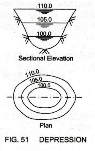
The series of closed contours with increase in elevation from inside to outside
in plan denotes a Depression. See Fig. 51.
8.
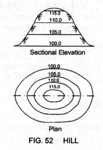
A series of closed contours with increase in elevation from outside to inside
in plan denotes a Hill. [Fig. 52.]
9.
Contour lines cross a Valley line at right angles. The contour lines form
V-shaped curves with their convexity towards the higher elevation, i.e.,
contours of lower elevations are inside the bend. The same contour appears
USES OF CONTOUR MAPS
1. Used to find the topography of the country.
2. Used to compute the quantities of earth work for any work.
3. Used to determine the catchment area of a river, lake or a reservoir.
4. Used to compute the storage capacity of reservoirs.
5. Used to select the most suitable projects such as a highway road, railway or canal, etc.
6. Used to trace out the drainage areas of a stream or a river.
Basic Civil & Mechanical Engineering: UNIT II: f. Contour surveying : Tag: : Contour surveying - Characteristics of contours
Related Topics
Related Subjects
Basic Civil and Mechanical Engineering
BE3255 2nd Semester 2021 Regulation | 2nd Semester EEE Dept 2021 Regulation