Basic Civil & Mechanical Engineering: UNIT II: c. Measurement of angles
Measurement of angles
Traverse Surveying or Traversing | Surveying
The direction of a survey line may be defined either (i) by the horizontal angle between the line adjacent to it, or (ii) by the angle called the Meridian and the line.
UNIT – II
Chapter - 3 (B)
MEASUREMENT OF ANGLES
To
plot a survey line on paper, its length and direction must be known. The direction
of a survey line may be defined either (i) by the horizontal angle between the
line adjacent to it, or (ii) by the angle called the Meridian and the line.
Meridian is the horizontal angle measured between a reference line and a survey
line. It is denoted in degrees.
In
the field work, angles are measured in degrees (o), minutes (') and
seconds ("). 1 rotation = 360°; 1° = 60'; and l' = 60”.
TRAVERSE SURVEYING or TRAVERSING
Two
methods of surveying are: Triangulation and Traversing. Triangulation
Method is used in chain surveying, when the area is small and flat. For
large areas, Traversing is adopted.
Traverse
Surveying is a survey consisting of a set of
connected lines whose Lengths and Directions are measured. The area to be
surveyed is connected by a number of lines forming the figure other than
triangle. The lengths of survey lines are measured using chain or tape. The
directions of survey lines are measured using angular measuring instruments
such as Prismatic Compass, Surveyor's Compass and Theodolite and fixed by
measuring the Bearings. The details are filled by taking offsets as in the case
of chain surveying.
Traverse
surveying is similar to chain surveying except the following:
•
The bearings of survey lines are observed to fix their directions.
•
The framework formed by survey lines need not be divided into number of
triangles.
1. TYPES OF TRAVERSE SURVEYING
1.
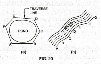
Closed Traverse: See Fig. 20(a).
A
traverse is said to be closed, if the survey lines close at the starting point
forming a closed polygon.
Closed
traverse is suitable for surveying, the boundaries of large area of land such
as a pond, lake, a village layout, forest, etc.
Wherever
possible, all traverses should be (b) closed. If not closed, there can be no
rigid check on the accuracy of the work.
Also,
since the lines form a closed polygon, we can check the sum of the interior
angles.
2. Open Traverse: See Fig. 20(b). A traverse is said to be open, if the survey lines do not close at the starting point to form a closed polygon. This traverse consists of series of lines running in the same direction. Open traverse is suitable for long narrow strip of works like highway roads, rivers and for laying water pipe lines, etc.
2. METHODS OF MEASUREMENT OF ANGLES
Angular
Measurement: The direction of survey lines in a
traverse surveying are the measurement of an angle from the preceding survey
line or from any reference line called Meridian. This type of measurements is
called Angular Measurement.
Horizontal
Angles are measured in different ways. In a closed
traverse along the perimeter of an area of land, interior angles are measured.
In open traverse, angles are measured in the following two ways:
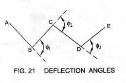
1.
Deflection Angle Method
Deflection
Angle is the angle that any line makes with the extension of the preceding
line. Such angles should be clearly identified as measured to the right
(clockwise) or to the left (anti-clockwise) from the extension of the preceding
line. ϕ1, ϕ2 and ϕ3 are the deflection angles
between successive lines. See Fig. 21.
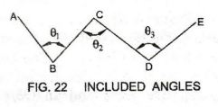
2.
Included Angle Method
Fig.
22 shows the included angles θ1, θ2 and θ3 measured clockwise from the back line to a
forward line.
Instruments
used for the measurement of angles are: Compass, Theodolite and Box
Sextant.
Basic Civil & Mechanical Engineering: UNIT II: c. Measurement of angles : Tag: : Traverse Surveying or Traversing | Surveying - Measurement of angles
Related Topics
Related Subjects

Basic Civil and Mechanical Engineering
BE3255 2nd Semester 2021 Regulation | 2nd Semester EEE Dept 2021 Regulation