Basic Civil & Mechanical Engineering: UNIT II: b. Chain surveying
Chain surveying operations
Steps involved in conducting chain surveying are: 1. Ranging, 2. Chaining and 3. Offsetting.
CHAIN SURVEYING OPERATIONS
Steps
involved in conducting chain surveying are: 1. Ranging, 2. Chaining and 3.
Offsetting.
1. RANGING A SURVEY LINE
Ranging
is done prior to Chaining. Ranging is necessary when the chain line is too
long. Sometimes, chain line exceeds one chain length. In such cases, it is
necessary to fix an intermediate point in line with the end points to measure
the length accurately.
Ranging
a Survey Line is the process of locating intermediate points in between the
terminal stations or extending a survey line beyond the terminal stations in a
straight line. It is done by fixing a series of pegs such that they all lie on
a straight line. Ranging can be done by Eye Judgment or by using Optical
Instruments such as Line Ranger or Theodolite.
1.
Methods of Ranging
(i)
Direct Ranging: Direct Ranging is the process of fixing
intermediate points in line with the two end points by making direct
observations from either of these points. This is possible when the end points
are inter-visible. It is carried out by following two methods:
•
Direct Ranging by Eye Judgment: (Fig. 14)

The
surveyor uses his eyes to fix an intermediate point C in line with the two end
points A and B. For this, two persons, Leader and Assistant, are required.
Leader stands with a ranging rod at A. Another ranging rod is erected at B.
Assistant
then goes with another ranging rod C at a distance not greater than one chain
length from A. Leader at A signals the Assistant to move his rod to the right
or left as required until the three rods appear exactly in the same straight
line.
•
Direct Ranging by Line Ranger: (Fig. 15)
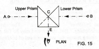
When
the distance is very long, Line Ranger is used. Line Ranger is a small reflecting
instrument used for fixing an intermediate point C between A and B. The line
ranger consists of two rightangled isosceles triangular prisms placed
To
locate C in line with the ranging rods of A and B, stand near C approximately
in line with A and B. Hold the line ranger at eye's level. Turn to see the
image of the ranging rod at A. Now, the ray from A enters the upper prism, gets
reflected from its hypotenuse and enters the Eye Hole E at right-angles to AB.
Similarly,
the ray from B enters the lower prism, gets reflected from its hypotenuse and
enters the Eye Hole E at right-angles to AB. Thus, the images of A and B are
seen in upper and lower prisms.
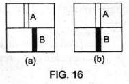
See
Fig. 16(a). If the position of C is not in line with AB, the images are seen
separated.
See
Fig. 16(b). Move the instrument forward or backward at right-angles to AB to
bring the images in the same vertical line, one above the other. C is in line with
AB. Transfer C to the ground using a plumb bob.
(ii)
Indirect Ranging
It
is the method of fixing an intermediate point between two end points, when they
are not inter-visible.
Inter-visibility
between the end points are obstructed due to (a) an obstacle such as a tall
building or a thickwooded forest or a valley and (b) the distance between the
end points may be too great to have a distinct visibility.
See
Fig. 17. A and B are not inter visible due to the rising ground between them. C
and D are the intermediate points to be fixed in line between A and B.
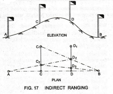
Select
two points C1 and D1 in between A and B at random such
that A and B are visible from them. Ask two persons with ranging rods to occupy
the positions C1 and D, such that A is seen from D1 and B
is seen from C1.
Now,
the man at C1 directs the man at D1 to come to D2
in line with C1B. The man at D2 directs the man at C1
to come to C2 in line with AD2. Again, the man at C2
directs the man at D2 to come to D3 and so on. Continue
the operations until both C & D are in line with AB.
2. CHAINING A SURVEY LINE
It
is the process of measuring horizontal distance between two points in a survey
line with a chain or tape. It is done after the process of ranging. For
chaining operation, two Chainmen - Leader and Follower - are required. The
chained distances can be plotted only when measured horizontally. But, the
ground may be flat or sloping. Even if the points are on a sloping ground,
chaining means the measurement of horizontal distance between them.
1.
Chaining along FLAT Ground
Ranging
rods are fixed at the ends of the line to be chained. Intermediate points are
located at less than one chain length. The leader takes the handle of the chain
and moves forward. The follower takes the other handle, places it in contact
with the starting station of the line.
Now,
the leader stretches the chain by aligning it with the above intermediate
points. He inserts an arrow into the ground at the end of the chain to indicate
one chain length. The leader then drags the chain in forward direction. The
follower follows him. He places the handle of the chain in contact with the
arrow and directs the leader to stretch the chain in alignment with the line.
The
leader now inserts another arrow at the end of chain handle to indicate second
chain length. The operation is repeated until the end station of the line is
reached.
2.
Chaining along SLOPING Ground
The
horizontal distance of a sloping ground is measured by Direct Method, when the
ground is not very steep and by Indirect Method, when the ground is steep. i)
i)
Direct Method or Stepping Method: See Fig. 18.
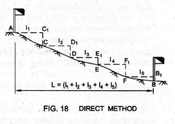
In
this method, the horizontal distance L between A and B along a sloping ground is
obtained directly by placing short horizontal lengths in the form of steps.
Hence, it is also known as Stepping Method..
Follower
holds the zero end of the chain at the starting point A. Leader stretches the
chain to a smaller length of l1 (=AC1) horizontally by
eye judgment. Leader then transfers the position Ci to C on the ground by dropping
a plumb bob or stone from C1.
Then,
the leader moves forward and the follower occupies the position C. The follower
again holds the zero end of the chain at C. The leader now aligns the chain in
line with AB and stretches it to a length of 12 (=CD1) horizontally.
The above procedure is repeated until the last point B is reached.
Therefore,
L = (11 + 12 + 13 + 14 + 15)
ii)
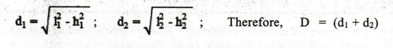
Indirect Method - By Measuring the Sloping Length and Difference in Elevations
In
this method, the horizontal distance D between A and B along a sloping ground
is obtained indirectly by calculation. See Fig. 19.

When
the slope of the ground is not uniform, divide AB into a number of sections
such as AC and CB. Measure the sloping lengths l1 and l2
of AC and CB respectively.
Also,
measure the difference in elevations h1 h2 between A, C & C, B respectively. d1
and d2 are found as:
3. OFFSETTING (Refer Fig. 13)
Offset
is the lateral measurement taken to the left or right of a survey line to
locate the details such as buildings, boundaries, roads, etc. The process of
marking the offset is Offsetting.
1.
Perpendicular Offsets: The offset taken at right angles
to the survey line is called Perpendicular Offset. A cross-staff or an optical
square is used to locate the foot of the perpendicular from any point or to
erect a perpendicular at any point.
2.
Oblique Offsets: An offset taken at an angle other than
90° to a survey line is calle Oblique Offset. The operation of taking oblique
offsets to locate a point involves the measurement of (i) Length and Angle or
(ii) Length only or (iii) Angle only.
4. USES or ADVANTAGES OF CHAIN SURVEYING
1.
Chain surveying is the simplest form of surveying. It requires no sophisticated
equipment.
2.
It is suitable when the ground is fairly level. 3. It is used to secure
necessary data for making plans of small areas. 4. It is used to determine the
area of land and to divide the land into a number of units.
5. LIMITATIONS or DISADVANTAGES OF CHAIN SURVEYING
1.
It is not suitable for larger areas with more and crowded details.
2.
It is not suitable for thick, bushy and wooded areas and areas with large ups
and downs.
3.
Errors: Errors in chaining are (i) Personal Errors caused due to inability of
the surveyor to direct the line of sight of the instrument exactly towards the
center of the object, (ii) Instrumental Errors caused due to imperfections in
the instruments, (iii) Natural Errors caused due to natural phenomena like
wind, temperature changes, etc.
Basic Civil & Mechanical Engineering: UNIT II: b. Chain surveying : Tag: : - Chain surveying operations
Related Topics
Related Subjects
Basic Civil and Mechanical Engineering
BE3255 2nd Semester 2021 Regulation | 2nd Semester EEE Dept 2021 Regulation